Mount Rushmore National Monument by Dave Hileman

I have now been here three times: once in the early 90’s for about an hour, on our way to Alaska in 2019, and briefly with my grandson in April of 21. I understand the scope of the work, the effort behind the dream, and the desire to honor significant leaders of the United States but it just doesn’t charm me. I am a clear minority in that opinion as the park is built for crowds. On our one longer visit, we walked the Presidential Trail directly under the enormous sculptures, took a tour of the artist’s studio, and enjoyed a ice cream at the Visitor Center/book store/gift shop/restaurant complex. Touring the site was worth the time, and the studio and walkway of state flags are both interesting. I don’t need another stop here but there is so much to see in the area that a fourth time... maybe.

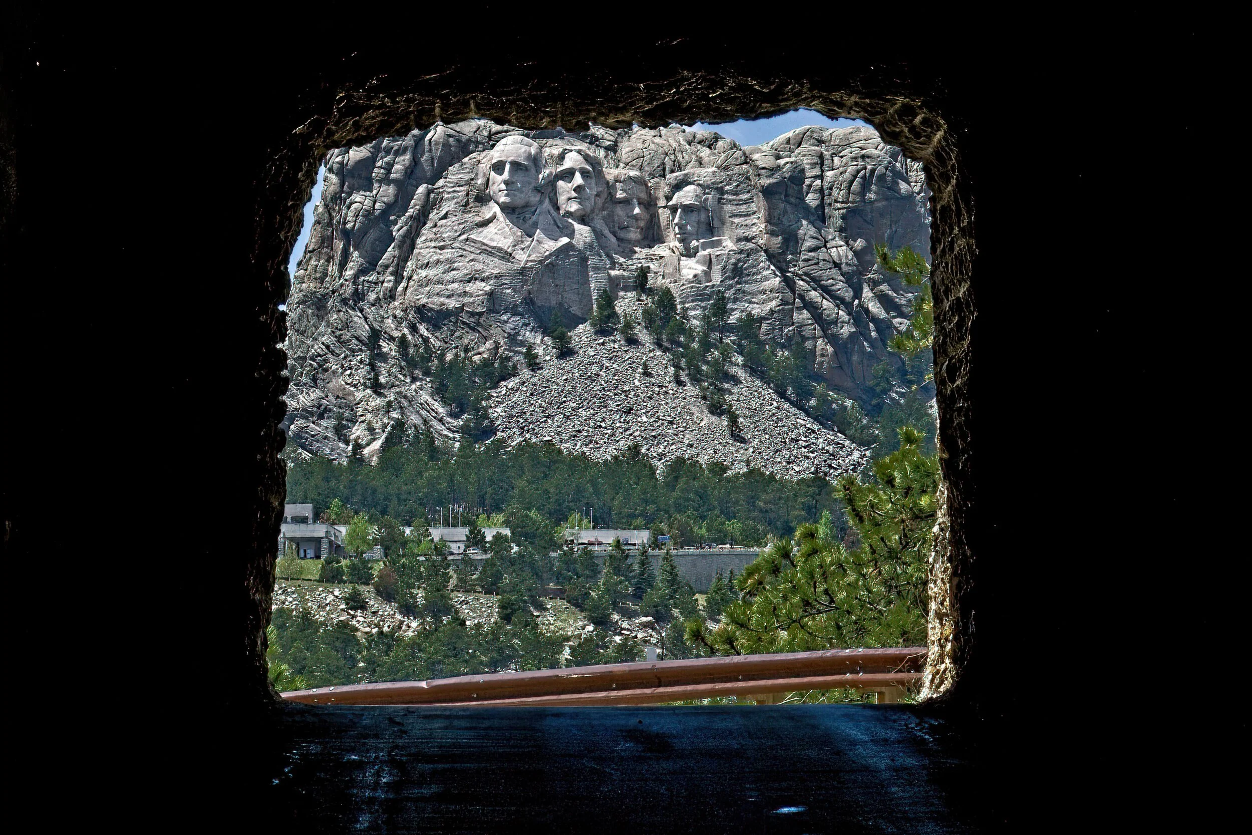
One of the neatest things was to approach Rushmore by way of the Iron Mountain Road. On it you encounter some good views and travel through two or three hand dug tunnels that frame the four faces.

The parking is on a multi-level pay lot which is a bit of a walk from the viewing platforms. They do have a Starbucks and, predictably, there was a line. But even more critically they have decent ice cream and feature Jefferson as the one who popularized ice cream in the US with a clever T-shirt or two.

Cadillac’s Viewpoint: This park is great. Good ice cream, lattes, A/C and comfy seats while the actual park is a short walk and all you have to do is look. Not sure who those guys are but a certain Moose would really brighten up the vista. Course then they’d need another parking garage. Cadillac’s Elevation 4+ Antlers

Rushmore 1DSCF1028-SAI-softness.jpeg
Rushmore 2DSCF1041-SAI-softness.jpeg
Rushmore 3DSCF1044-SAI-softness.jpeg
Rushmore 5DSCF1053-SAI-softness.jpeg
Rushmore 4DSCF1049-SAI-softness.jpeg

Minuteman Missile National Historic Site by Dave Hileman

This is a site I was looking forward to seeing. Growing up in the 50’s, these were a big deal in the news in a secretive sort of way with no details but “we have this arsenal ready.” However, access to descending into the “tube” had very restrictive hours with reservations in advance. I missed that detail so we toured only the outside of four of the Minuteman sites in the area and were able to enjoy the Visitor Center.

This is a park we will return to someday with preparations in advance.

There was a missile silo site not too far from where I lived in Western Pennsylvania that closed when I was a teenager. Someone “may” have visited that place after it closed.

Cadillac’s Viewpoint: There was nothing there to see. Who can figure out the Driver? Cadillac’s Elevation 0 Antlers

Minuteman 1DSCF1346-SAI-softness.jpeg
Entrance to one of the sites. Still lots of security just no guns.

Entrance to one of the sites. Still lots of security just no guns.

This is the silo you can tour

This is the silo you can tour

Badlands National Park by Dave Hileman

We really enjoyed this extensive park, at first glance seemingly desolate, but actually full of life and beauty with a great history. Located in southwestern South Dakota, it is very close to other NPS sites and excellent state parks as well.

We hiked on three trails in the park. The Fossil and the Castle trails were the most scenic. We drove several miles on the loop road with a long stop at Robert’s prairie dog town. Super interesting to watch these cute-at-a-distance critters. We also saw bison, mountain goats, and pronghorn. There was a small area near the campground where water was trapped and the birds were abundant.

We camped in the park at Cedar Pass in the National Park. No services but decent older style where the loop road widens to create a campsite. This kind of site is tight for the larger rigs and slideouts of current RV’s but was not an issue for us.

Our stop here included two visits to the infamous Wall Drug for their 5 cent coffee in a real cup with real cream (and donut - additional charge). We visited the nearby NP Minute Man Missile site. See under Minute Man in South Dakota.

Cadillac’s Viewpoint: There were a lot of minor antlered animals and they clearly looked to me for leadership but a bit too dry and remote for me. The donuts were a plus. Cadillac’s Elevation 2.5 Antlers

Rugged and stunning country

Rugged and stunning country

Badlands 1DSCF1113-SAI-softness.jpeg
Is anything more iconic than two vultures on a cliff in the Badlands?

Is anything more iconic than two vultures on a cliff in the Badlands?

Teaching the kids how to hide with her warnings.

Teaching the kids how to hide with her warnings.

Barely visible on the right side near the bottom is a young women counting the Dogs, she was with six other people.

Barely visible on the right side near the bottom is a young women counting the Dogs, she was with six other people.

Big Horn Sheep

Big Horn Sheep

Waiting for the light

Waiting for the light

Waiting for sunset

Waiting for sunset

Handy sign when you come to a cliff and see no more trail.

Handy sign when you come to a cliff and see no more trail.

Wall Ddrug coffee and donut

Wall Ddrug coffee and donut

Alaskans by Dave Hileman

They tend to live in a rhythm of their own making. This shed or perhaps house was in a back alley in Skagway, Alaska. Love the creative bird houses.

“Don’t copy the behavior and customs of this world, but let God transform you into a new person by changing the way you think. Then you will learn to know God’s will for you, which is good and pleasing and perfect.” Romans 12:2 NLT

Skagway 3DSCF2614-SAI-softness.jpeg

Poverty Point National Monument (& World Heritage Site) by Dave Hileman

We have visited several NPS units that are focused on mounds but this was the most unique. Poverty Point is located in a remote, rural part of Northeastern Louisiana not too far from Vicksburg, MS. The park consists of several mounds dating from about 2000 BC, some quite large and some configured in concentric “C” shapes with the open end facing the largest mound. This park’s Visitor Center was open - it included an interesting but small museum. There are trails here across both open and wooded land. The Park Service constructed steps to the top of the large mound; from there you can see many of the mounds and the stadium-like area where the “C” mounds were constructed. It took tens of thousands of baskets of rock and soil to build these earthen platforms, and no studies have completely verified their purpose. The large mound had a secondary flat space that they believe was used for sport. We also did a five mile driving tour through the park.

We camped in Poverty Point Reservoir State Park a few miles south of the park. We also visited the Chennault Aviation and Military Museum in Monroe, LA. Many of General Chennault’s personal items were on display, and several aircraft were being restored at an adjacent facility.

Cadillac’s Viewpoint: I did look good standing on top of the tall mound where, if I were king, I could look at my subjects. But I have not found out how to run for king …yet. Cadillac’s Elevation 1.5 Antlers

Walkway to the top of the largest mound

Walkway to the top of the largest mound

Poverty PY 2DSCF2552-SAI-softness.jpeg
View from the top. There are several smaller mounds around the property

View from the top. There are several smaller mounds around the property

The “C” shaped mounds, a partial view

The “C” shaped mounds, a partial view

President William Jefferson Clinton Birthplace Home National Historic Site by Dave Hileman

I am unsure of where to start on this park, so I will begin with a confession: I did not like President Clinton’s policies and later was appalled at his disgraceful conduct in the Oval Office. That is my bias at this park site. However, he was one of this nation’s presidents, so it is appropriate for the park service to preserve a site related to his family history. He lived here in his grandparents’ house for less than four years while his mother finished nursing school. After she remarried, they moved to Hot Springs where he lived for 15 years until leaving for Georgetown.

The park is a small city block with the home and a smaller house next door that serves as a VC where the exhibit consists of 8 banners about people from the area who influenced President Clinton’s early life. The house was closed because of Covid so our experience there was very limited. A four lane city street a few feet in front of the house and railroad tracks beside it reduced parking to a few spaces on the side street in front of the VC. Tough with the trailer. This site could develop as an interesting place over time but it is not there yet. And a bit of the effort to make it seem so is kinda overblown like the statement that this is where he developed his “broad views on race relations, social justice, and public service that defined his presidency” Not likely at 3 and a half. However, “The Man from Hope” was a good campaign slogan. He did achieve his ambition rising from these humble beginnings.

Cadillac’s Viewpoint: Sorry, I was still reading the name of the park when they finished. Cadillac’s Elevation 0 Antlers

Hope ak 2DSCF3099.jpg

Glacier Bay National Park by Dave Hileman

Glacier Bay National Park

There are days of long-planned travel to places that slightly disappoint, and there are others where the grandest expectations are exceeded by reality. Flying over Glacier Bay National Park is definitely the latter. What a magical afternoon!

We drove toward Skagway from the Yukon and entered Alaska for the first time headed for the Klondike Gold Rush National Historical Park. Our original plan was to see Glacier Bay on a flight from Haines, AK with Mountain Flying Service. However, we found their booking office in Skagway and were offered the flight at the same reduced price as going from Haines. It was a gorgeous crystal clear day, and we made the great choice to go ahead.

The plane, a DHC-2 Beaver, was very cool and meticulously maintained by the company owner/ pilot, Paul, who has been doing this for years. We joined a family of four from France for the last flight of the day which was extended 30 minutes because of the beautiful weather, a total of 3 hours with 75 minutes over Glacier Bay Park.

The views were amazing: ice and snow stretching for miles, mountains on every horizon, and occasional glimpses of the Pacific Ocean, bays and lakes glistening in shades of green and blue. The plane dipped into small valleys and banked against high, snow covered cliffs. Enthralling and magnificent!

There are basically three ways to see Glacier Bay Park: On a cruise liner, (my last choice), on a National Park boat day trip from a tiny town on the edge of the park reached by a flight from Juneau (about equal in expense with the flight we took), or the small plane “flight-seeing.”

When we landed, we found Skagway almost empty as most of the tourists had departed for the cruise ships. We enjoyed dinner at Skagway Brewing Company before the two hour drive back to our campground in Whitehorse, Yukon on the scenic Klondike Highway. Passing through customs both directions was easy. A stunning day with many hours of daylight and a highlight of our Alaska trip.

TLT Evaluation - Glacier Bay National Park - Breathtaking 5/5,

Cadillac’s Viewpoint: What is not to like. I am such a skillful aviator - the day was perfect. Cadillac’s Elevation 5 Antlers

Glacier Bay 8DSCF2524.jpg
Up top and up close

Up top and up close

A dramatic glacial river

A dramatic glacial river

We dipped low over this area and on that bridge in three days I would photograph eagles and a bear a bit to the right of the photo

We dipped low over this area and on that bridge in three days I would photograph eagles and a bear a bit to the right of the photo

Two glacial “rivers’ merge at the dark stripe

Two glacial “rivers’ merge at the dark stripe

This glacier ends on land so just melting ice seeps into this bay

This glacier ends on land so just melting ice seeps into this bay

This glacier ends in the water so the edges calve - they are 200 to 300 feet high and note the water color change.

This glacier ends in the water so the edges calve - they are 200 to 300 feet high and note the water color change.

Arkansas Post National Memorial by Dave Hileman

The confluence of the Arkansas and the Mississippi Rivers in eastern Arkansas was a gathering place for native Americans for generations. In the early 1700’s, Spain laid claim to this area and established a small fort. There was a brief battle here between the Spanish and the English during the Revolution. After the sale to the US in the Louisiana Purchase, settlers begin to move into the area. The Arkansas Post became the capital of the territory, and the town grew to nearly 1000 people. No buildings remain but you can walk a staked path that shows where structures would have been. The Confederates built an extensive earthen works fort here but it was surrendered to the Union troops. Few people lived here after the war, and a change in the river’s course hastened the end when steamships could no longer dock.

The Arkansas Post has a VC (closed for Covid), three miles of trails, lots of wetlands, and a few remnants of the Confederate earthen works.

There is also a state historic park of the same name with a few reconstructed buildings and a log cabin built for a caretaker in the National Park in 1931 that has been moved to the state site.

We stayed near here at Pemberton Park Corps of Engineers campground right on the Arkansas River.

Cadillac’s Viewpoint: Nice, placid wetlands and lovely plants to enjoy for a snack. Zero coffee, zero ice cream and zero food for miles in any direction. Cadillac’s Elevation 1 Antler

Arkansas Post 3DSCF2627-SAI-softness.jpeg
Arkansas Post 2DSCF2624-SAI-softness.jpeg
Arkansas Post State 1DSCF2588-SAI-softness.jpeg
Arkansas Post State 2a areaDSCF2667 copy-SAI-softness.jpeg

Cane River Creole National Historical Park by Dave Hileman

We visited two NP historic plantations whose land grants predate the US. They were farmed for nearly 300 years before being given intact to the Park Service. We were not permitted in the houses because of Covid but many of the buildings and all the grounds were open at both Oakland Plantation and Magnolia Plantation. Very intriguing places with fascinating intertwined histories.

We toured the reconstructed Fort St. John Baptist with their well done museum in Natchitoches and did a walking tour of the town. Some of the “down river” private sites were not open but we still enjoyed the scenery along the Longleaf Scenic Byway and St. Augustine Catholic Church was well worth the stop.

The night before we arrived at the Cane River Creole National Historical Park was spent at a remote blueberry farm - a Harvest Host site. We arrived at Natchitoches, LA from a tiny country road that merged onto the main street along the river into a wonderful little town. Their history predated New Orleans with fabulous architecture, the French fort, the house where Steel Magnolias was filmed, and the oldest hardware store in LA - still in the original building. We camped at Pecan Orchard RV park.

We had coffee at the Story Time Cafe in town, a very good dinner at the Cane River Commissary close to the plantations and, to top things off, there was a car show in town by the river. A very nice town in a beautiful area with so much more to see. Hope we get back some day.

Cadillac’s Viewpoint: The Cane River was great, good food, good coffee, good ice cream, fancy cars and, of course, we left after two days. The Driver will never win reelection at this rate. Wait that’s a good thing! Cadillac’s Elevation 4.5 Antlers

Main house at Oakland Plantation

Main house at Oakland Plantation

The Commissary (general store) at Oaklands

The Commissary (general store) at Oaklands

Typical high roof open shed

Typical high roof open shed

The overseer’s house at Magnolia Plantation, later a tenant farmer’s home until the 1970s

The overseer’s house at Magnolia Plantation, later a tenant farmer’s home until the 1970s

Enslaved person’s home at Magnolia

Enslaved person’s home at Magnolia

Natchez National Historic Park by Dave Hileman

A Natchez resident replied to our compliments on her beautiful city:  “That is what happens if you surrender instead of fighting like Vicksburg did - you preserve your history.” The difference between the two towns is striking. Only about 75 miles apart, both on the banks of the Mississippi River, Vicksburg appears to not yet be fully recovered from the Civil War, while Natchez is quite attractive and seems prosperous. 

The National Park consists of six sections: Forks of the Road, Fort Rosalie, Melrose, the William Johnson House, the Natchez Visitor Center, and the preservation district. We toured the grounds at Melrose, an 1840’s plantation home. 2020 protocols closed most of the indoor sites including the Johnson House and Forks of the Road. The main VC was partially open. By the time we arrived at Fort Rosalie, walking the grounds was out due to very heavy rain.

his was our second visit to Natchez but the first to the National Park sites. We did explore a beautiful & historic private home, Rosalie, near the fort of the same name. Well done. There are 8 National Register of Historic Places districts and 13 national historic landmarks inside the city. We look forward to seeing them when indoor touring is available.

We camped at a Boondocker Welcome site a bit north of Jackson, MS, right along the Natchez Trace.

Cadillac’s Viewpoint: Big plus is being right on a river and the houses had appropriate ceilings for my lovely antlers but no stops for lattes or ice cream. Cadillac’s Elevation 3.5 Antlers

Natchez 2DSCF2382-SAI-softness.jpeg
Natchez 3DSCF2409-SAI-softness.jpeg
William Johnston House

William Johnston House

The fort grounds

The fort grounds

Mighty by Dave Hileman

This is one of dozens of waterfalls in Western NC - Southeastern TN and Northeastern Al and Northwestern GA that draw people to the area. One of the beautiful regions that we never tire of visiting.

“So humble yourselves under the mighty power of God, and at the right time he will lift you up in honor.”

1 Peter 5:6 NLT

NC Waterfall 2DSCF4520.jpg

Towering by Dave Hileman

This is a view of the Eastern slope of the Sierra Nevada Mountain range as seen from the Alabama Hills. I was able to walk about 1/2 mile in the area that felt so wild. Loved this shot.

AL Hills 2DSCF1877-SAI-softness.jpeg

Russell Cave National Monument  by Dave Hileman

In the Southeast United States, this cave holds the oldest record of occupation by cultures of prehistoric Indians beginning about 10,000 years ago. The very large mouth of the cave led to smaller chambers and then on to over 7 miles of passages. The cave provided substantial shelter, particularly in the winter, and the mile of stream inside the cave provided year round water. The abundant nuts, berries and wildlife sustained the 30 or so families who made this their home. Digs were done here in the 1950’s when the scope of the importance of this site was recognized. Several of the objects recovered are in the small but well done museum in the Visitor Center. 

The cave is located in Northeastern Alabama almost on the Tennessee line. 

This was a short visit as heavy rain kept us off the single mile and a half trail. We did walk the nature trail and the path to the cave entrance. Guests are no longer permitted inside the cave nor is spelunking allowed. We were camping about 35 miles away in DeSoto State Park so this was a good half day trip. On a pretty day there is a nice picnic spot. 

Cadillac’s Viewpoint: This has Moose potential but I don’t like caves. There is simply no place for magnificent antlers such as mine. Cadillac’s Elevation 1 Antler

Al Cave 1DSCF4282-SAI-softness.jpeg
Al Cave 2DSCF4284-SAI-softness.jpeg

Hot Springs National Park by Dave Hileman

Hot Springs is one of the smallest national parks in the system and also the oldest - it was protected by the federal government in 1832 before the concept of a national park existed. The park includes two downtown bathhouses on Bathhouse Row, the Promenade, a park, a small campground, some drive accessible mountains, and about 30 miles of hiking trails. The NPS manages the hot springs regulating temperature and protecting the springs. 

Lots of cool things to see and learn in the National Historic Landmark District of the town in addition to the National Park. Gangsters of the early 20th century declared the resort neutral ground where they could hang out without war between rival groups. Baseball spring training originated here about the same time.

We throughly enjoyed this area - the walking tour, park, shops and Promenade in town, the drives to West Mountain for a sunset and Hot Springs Mountain, the Gulpha Gorge, Sunset, and Goat Rock Trails. The Gulpha Gorge NP Campground was very nice - no reservations but auto check-in worked well. We needed to replace the sail switch on our furnace and received exceptional service from Livingston RV on the edge of town.  

We filled water bottles at the free hot spring where the water was over 110 degrees. It was fantastic, and the coffee we made with it was absolutely the best. We had super root beer (made from the local water) floats at the Superior Bath House Brewery. We liked it so much we went back for dinner - good food and interesting historic setting. We enjoyed peanut butter and cafe latte ice cream at Scoops, better than ok but not quite a top ten contender. 

Cadillac’s Viewpoint: Now this is a National Park! Nice woodlands, streams and ponds yet close to lattes (the motherlode of lattes) and ice cream. They also have INDOOR hot and steamy ponds. That you can soak in! And I have discovered an elixir called Root Beer. Spectacular with ice cream. So, how long do you think we spent in paradise? Three days! That is days not months. Three. Here. I know who sets this crazy schedule and I think his poll numbers are awful right now.  Cadillac’s Elevation 5 Antlers

Hot Springs 4DSCF2878.jpg
The

The Promenade

One of the few “open” hot springs so one might see what the pools were once like

One of the few “open” hot springs so one might see what the pools were once like

Moonrise over Hot Springs. The enormous building is the military hospital

Moonrise over Hot Springs. The enormous building is the military hospital

View from Goat Rock

View from Goat Rock

Cadillac’s Heaven

Cadillac’s Heaven

Little Rock Central High School National Historic Site by Dave Hileman

This is a very moving site which focuses on the integration of the school in 1957 by nine courageous black students and the efforts to keep them from attending. A highlight of the museum is the presentation of video from both 1957 and retrospective interviews from much later in the nine students’ lives. Through the large windows in the excellent Visitor Center, you could see both the high school and the gas station where the media were clustered.

We arrived early on a Sunday morning, a benefit for visiting park sites in larger cities to avoid the most traffic and find parking when towing a trailer. Apple or Google maps street view is a help with parking. Early arrival at the the museum was good since the limit was set at 6 visitors. The tour of the high school - still in use today - was canceled because of Covid concerns.

Cadillac’s Viewpoint: Once again, I am in favor of rights civil, natural, Moose et al. Seems to me that school is not that critical - I mean look at how successful I am with no actual schooling. I don’t really count that time at the CIA learning to cook. Of course, I am a Moose. Cadillac’s Elevation 4 Antlers

Little Rock 5DSCF2741.jpg
Little Rock 2DSCF2725.jpg
Little Rock 4DSCF2734.jpg

Horseshoe Bend National Military Park by Dave Hileman

The battle that took place here on March 27th of 1814 was the last of the Creek Wars. At Horseshoe Bend in the Tallapoosa River, the Northern Red Stick warriors built a fortified log wall to protect their village. They numbered about 1000 men, and their women and children were in the village a few hundred yards away.

Andrew Jackson attacked their position first with a cannon bombardment that proved ineffective against the strong fortifications. However, he sent about 1/3 of his troops and Indian allies across the river to attack the rear through the village when the cannons were fired. Jackson then ordered a bayonet charge that breeched the wall. Caught between the two wings of the army, the Red Stick warriors began a fighting retreat toward a woodland hill but they proved no match for the soldiers at that point. 

It was an overwhelming victory for Jackson. While his losses were about 200, the Red Sticks lost between 550 and 800 warriors, and the last serious threat was broken. Millions of acres of land in the South was ceded to the US and, eventually, the survivors joined the long trek on the Trail of Tears. 

The park is easy to access on paved roads and rather simple to grasp the scope of the battle as most of it can be viewed from one site. You can see a line where the barricade was built, the hill where the cannon were located, and follow the entire five hour fight from beginning to end. The river flows quietly past the site of the village. We were unable to enter the VC but there is a museum inside. 

This is just below where the cannon were place and where the main body of troops began the charge. The white posts indicate the line of the fort.

This is just below where the cannon were place and where the main body of troops began the charge. The white posts indicate the line of the fort.

Horsewhoe Bend 4DSCF4140-SAI-softness.jpeg
The only marked grave onto site

The only marked grave onto site

The Tallapoosa River

The Tallapoosa River

Little River Canyon National Preserve by Dave Hileman

This park is located in the northeast section of Alabama in the foothills of the mountains at the south end of Lookout Mountain. The primary tour is a scenic road that twists and turns for 11 miles on the western edge of the canyon. There are eight overlooks with some short walks and views of the river and ridges that stretch beyond the canyon rim. The road is not open to RVs because of the many tight, blind curves. At one point, we could see other people across the way and wondered how to get where they were. Then we realized the road was so twisty that we had actually been there on the previous stop. We skipped the one longer hike due to off and on rain. Other popular activities here include swimming, rock climbing and kayaking..

We camped in the nearby DeSoto State Park, a popular place with hiking and its own famous waterfall. Nice hikes and a good place to stay in a remote and beautiful area.

LORC NPS 3DSCF4161-SAI-softness.jpeg
LORC NPS 4DSCF4183-SAI-softness.jpeg
LORC NPS 5DSCF4194-SAI-softness.jpeg
LORC NPS 6DSCF4206-SAI-softness.jpeg
LORC NPS 8DSCF4233-SAI-softness.jpeg
Bonus Coverage: DeSoto State Park - same water system this is just upstream from the National Park - two photos

Bonus Coverage: DeSoto State Park - same water system this is just upstream from the National Park - two photos

Bass Harbor Light House by Dave Hileman

One of the more photographed places on Mount Dessert Island, Maine where Acadia National Park makes up about 1/3 of the island. I have shot this place in the morning, evening and mid-day. Always pretty.

“Be dressed for service and keep your lamps burning, as though you were waiting for your master to return from the wedding feast. Then you will be ready to open the door and let him in the moment he arrives and knocks.” Luke 12:35, 36 NLT

acadia 3DSCF9644-SAI-softness.jpeg

Quiet Day on the Lake by Dave Hileman

This tiny boathouse is on a lake in the DeSoto State Park in northeast Alabama’s mountains. The lake was a failed hydro-electric project when an attempt was made to deepen the lake with a high and ugly metal dam. Below the day were two different waterfalls that are an attraction to the area.

Desoto SP 4aDSCF4271-SAI-softness.jpeg

Birmingham Civil Rights National Monument  by Dave Hileman

Covering four city blocks in Birmingham, Alabama, this area has been in the National Park system only since 2017 and is the mid stages of development for visitors. The A. G. Gaston Motel, headquarters in 1963 for the local civil rights movement, will become a VC and museum.

Today you can visit Kelly Ingram Park, the center of the widely televised protests. The park is filled plaques and statues representing the struggle that took place here. Directly across the street is the 16th Street Baptist Church where a bomb set off by the KKK killed four little girls and greatly influenced the passage of the Civil Rights Act of 1964. It is a short walk to the Birmingham Civil Rights Institute - an affiliate of the Smithsonian and a partner with the NPS. Indoor sites were closed because of the 2020 health concerns. We hope to return when the VC and Institute are open.

We stayed at Oak Mountain State Park about 8 miles from town. We found camping in the Alabama state parks to be reasonable, clean, well marked and very busy. We came to Birmingham for a friend’s wedding so had no need for restaurants after the wonderful rehearsal and reception dinners. The bride recommended the huge delicious cookies from Cookie Fix.

Kneeling Ministers statue

http://www.bhamwiki.com/w/Three_Ministers_Kneeling

Birmingham Civil Rights

https://www.nps.gov/places/birmingham-civil-rights-institute.htm

B-CR 3DSCF2346-SAI-softness.jpeg